The Hike House

Wednesday, March 29th, 2023
Hiking Preparedness + Energy Supply + Apparel & Gear
  • Home
  • Sedona Trail Finder
    • About Sedona Trail Finder
    • List of 101 Sedona Hiking Trails
  • Hiking Preparedness
  • Energy Cafe
  • Trail Apparel
  • Grand Canyon Planning Station
  • Guided Hikes
  • Contact Us

Huckaby Trail

Wednesday, May 4, 2011 by The Hike House 8 Comments

The Hike House Sedona Trail Rating System
Huckaby Trail

This trail, constructed in 1998, is never far from the sights and sounds of Sedona. It is a pretty trail which offers a variety of views. It can be hiked from the Schnebly Hill trailhead (as described herein) or from Midgely Bridge. The trail is nearly level for 1/8 mile. The Margs Draw trail forks off to the left. Huckaby continues ahead and soon descends rather steeply, crosses Bear Wallow Wash, then ascends moderately over the next 1/2 mile. It tops out on a ridge and winds on level ground with nice views over Oak Creek and uptown Sedona to many of the familiar red rock formations of the area. 

At the 1 mile point, the trail curves around the top of Mitten Ridge with Steamboat Rock, Wilson Mountain and Midgely Bridge coming into view beyond the creek below. Then, it begins a moderate descent over the next 1/2 mile to the floodplain of Oak Creek. the trail goes north beside the creek for 1/2 mile in the partial shade of the riparian trees.

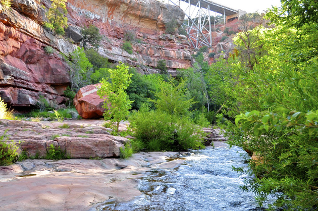
At 2 miles, opposite the north end of Midgely Bridge, the trail crosses a branch of the creek which requires wading or boulder hopping. Do not cross if the water is high. The trail continues north for 0.2 miles, then another boulder hop of the west branch is needed. The trail now climbs moderately over switchbacks, passes beneath Midgely Bridge, and ends at the parking area at the north end of the bridge. The trails is mostly unshaded except along the creek and can be hot in summer. Return by the same route or do one way in either direction with arranged transportation.

Trail Data

Distance: 2.6/5.2 miles (One way/Round Trip)
Time: 2.5 hours (Round Trip)
Elevation Change: 500 ft.
Difficulty: Moderate
Map: Click here for a map of Huckaby trail.

Trail Rating

VN:RO [1.9.8_1114]
Overall
Views
Difficulty
Rating: 3.3/5

View the HuckabyTrail Slideshow and Commentary

Huckaby Trail Image

Sedona Trail Rating System

The Hike House Sedona Trail Rating System provides actual hiker feedback and ratings of each of the Sedona hiking trails. The cumulative trail ratings for the Huckaby Trail submitted by fellow hikers is located above with the Trail Data. Your trail feedback and ratings are an important resource for fellow hikers and provide a personal account of your trail experience from which others may learn. So please hike Sedona, help others, and rate a trail today!

Filed Under: Sedona Trail Rating System Tagged With: hiking sedona, Huckaby Trail, The Hike House

Comments

  1. Scott Stevenson says:
    Sunday, June 19, 2011 at 2:30 pm
    Overall
    Views
    Difficulty

    Great trail that brings in some beautiful parts of Oak Creek. Normally would rate this a 2 difficulty but the start from Schnebly Hill has some elevation and length so rating it a 3 on difficulty. Fun part of trail is attempting to cross creek as you approach Midgely Bridge…several places you can attempt to cross if water levels not too high.

  2. Greg Armstrong says:
    Sunday, September 4, 2011 at 10:36 pm
    Overall
    Views
    Difficulty

    This was a fun little hike. We started from MIdgely bridge and began our hike down to Oak creek. There are steep switchbacks headed down, so keep that in mind as you have to make your way back up! Once down by the creek the trail gets very calm with the sound of the rushing creek. Take some time to dip your feet in the cool water. Work your way down the trail deeper into the canyon and along the creek. Depending on the water levels there are some fun areas to stop and relax along the creek. Its easy to lose the trail so have a map handy.

  3. Jessica says:
    Sunday, November 13, 2011 at 9:42 pm
    Overall
    Views
    Difficulty

    Beautiful hike! Loved the creek!

  4. Jason Creed says:
    Saturday, November 19, 2011 at 10:13 pm
    Overall
    Views
    Difficulty

    We had a great time hiking this trail today. The distance was just what we were looking for. This was our first hike in Sedona and we enjoyed it very much.

  5. Janelle Sparkman says:
    Wednesday, May 2, 2012 at 8:53 pm
    Overall
    Views
    Difficulty

    A little more difficult with the Schnebly Hill start. Lots of up and down. Good views of both Sedona and red rocks. Full sun until you get down to the creek area. Did not cross over to Midgley Bridge trailhead. Return trip does seem more uphill. A very interesting trail and we’ll do it again.

  6. Seymour says:
    Sunday, June 16, 2013 at 9:20 pm
    Overall
    Views
    Difficulty

    I’m an out of shape 50+. I hiked this from the Schnebly Hill Road trailhead in 70-80 degree weather and had my wife pick me up at the Midgely bridge parking lot. It took me 2.5 hrs one-way – stopping for pictures and rests in the shade.

    The early half of the hike offered little shade and involved some easy climbing. Walking around uptown on the trail was very neat. After you pass uptown the trail dips down to the creek. It gets shadier and much cooler. The sound of the creek here is lovely. I managed to cross the creek by rock hopping without getting any wetter than I chose. (sticking your hands or feet into the cool water is a real treat on a warm day). The climb up to Midgely bridge looked daunting but the switchbacks made it doable. Great views of the mountains, uptown Sedona and Oak Creek. I really enjoyed this hike.

  7. Renee says:
    Tuesday, February 7, 2017 at 11:24 pm
    Overall
    Views
    Difficulty

    Relatively easy trail with good scenery. Not overly populated with a good final destination. We are close to 60 and pretty much perfect for moderate intensity for not super athletic hikers.

  8. Renee says:
    Saturday, February 11, 2017 at 11:26 pm
    Overall
    Views
    Difficulty

    We liked his one. Nice destination with good scenery and relatively easy hike.

Tell us what you are thinking... Cancel reply

Your email address will not be published. Required fields are marked *

Sedona Trail Rating System Key

Rate this trail:
Overall
Views
Difficulty

Sedona's #1 Hiking Guide Book
Discover the "Top 30 Trails"

Book a Guided Hike Adventure

Diabetic Boot Camp
Trail Experience of the Month
Sedona Hiking Clinic

Sedona Trail Rating System

  • Review Trail Ratings
  • Rate a Hiking Trail

Hike House Videos

  • The Hike House's 5 Elements
  • Sedona Trail Finder
  • The Hike House Channel on Youtube

Sign up for our Email Newsletter Email Newsletter icon, E-mail Newsletter icon, Email List icon, E-mail List icon

News

  • Hogs Trail
  • Hi Line Trail
  • Hangover Trail
  • Biological Soil Crust: Holding the Place in Place
  • Capturing Sedona’s Beauty

Like Us On Facebook

Latest Article

Hogs Trail

Wednesday, May 18, 2016 1 Comment

Hogs Trail One of the most underrated areas in Sedona is Munds Wilderness. Many people in the past would take on this area because the predominant trail for this area, Broken Arrow, is adjacent to a heavily traveled jeep road. A new day has arrived…while you still must hike a portion of Broken Arrow to get to Hogs, the trail departs from the … [Read More...]

Our Location


The Hike House
431 State Route 179
Sedona, AZ 86336
928-282-5820
Hours of Operation
Mon-Sat 9:00 am - 6:00 pm
Sunday   9:00 am - 5:00 pm
Click here for Map.

Return to top of page
© 2023 The Hike House
Log in