The Hike House

Sunday, February 5th, 2023
Hiking Preparedness + Energy Supply + Apparel & Gear
  • Home
  • Sedona Trail Finder
    • About Sedona Trail Finder
    • List of 101 Sedona Hiking Trails
  • Hiking Preparedness
  • Energy Cafe
  • Trail Apparel
  • Grand Canyon Planning Station
  • Guided Hikes
  • Contact Us

Soldiers Pass

Sunday, May 29, 2011 by The Hike House 8 Comments

The Hike House Sedona Trail Rating System
Soldiers Pass

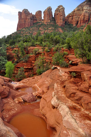
This trail provides a diverse experience beginning in an urban setting and eventually leads into Red Rock Secret Mountain Wilderness, increasing the potential for solitude. The first half of this trail is often busy and there is jeep tour traffic nearby. Enter at the signed trailhead which is open only from 8 a.m. to 6 p.m. The trail dips to cross a wash then climbs out to the Devils Kitchen sinkhole just off the trail to the right at 1/4 miles. The trail then goes over level ground for 1/4 mile to the “Seven Sacred Pools” (pictured on right) to the left of the trail. 

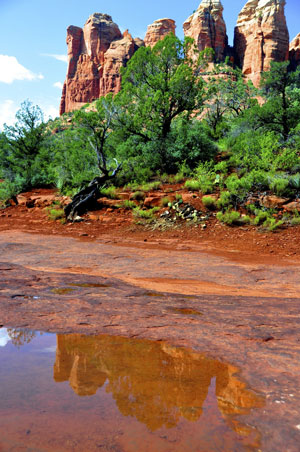
It continues on in the partial shade of Arizona cypress and intersects the end of a jeep road at 1.2 miles. The trail forks at the wilderness area boundary sign 1/8 mile further on. The right branch leads up rather steeply for 1/4 mile to an arch. Great views. The left branch is the main trail. This leads out of the wash on a moderate grade. Most of the shade is lost, but the views open up. The trail becomes increasingly steep and rocky as it climbs to the pass. Nearing 2 miles, it levels out on top of Brins Mesa, then continues for another 1/4 miles where it intersects Brins Mesa trial. Ultimately, scenic vistas can be enjoyed south into Sedona and north into the wilderness and the red cliffs of the Mogollon Rim. Return by the same route for a 4.5 mile round trip hike.

Trail Data

Distance: 2.4/4.8 miles (One way/Round Trip)
Time: 2.5 hours (Round Trip)
Elevation Change: 450 ft.
Difficulty: Moderate
Map: Click here for a map of Soldiers Pass trail.

Trail Rating

VN:RO [1.9.8_1114]
Overall
Views
Difficulty
Rating: 3.7/5

View the Soldiers Pass Trail Slideshow and Commentary

Soldiers Pass Trail Image 1
Soldiers Pass Trail Image 2

Sedona Trail Rating System

The Hike House Sedona Trail Rating System provides actual hiker feedback and ratings of each of the Sedona hiking trails. The cumulative trail ratings for the Soldiers Pass submitted by fellow hikers is located above with the Trail Data. Your trail feedback and ratings are an important resource for fellow hikers and provide a personal account of your trail experience from which others may learn. So please hike Sedona, help others, and rate a trail today!

Filed Under: Sedona Trail Rating System Tagged With: hiking sedona, Soldiers Pass, The Hike House

Comments

  1. Chris Weinkauff says:
    Thursday, June 23, 2011 at 10:57 am
    Overall
    Views
    Difficulty

    I ran the Soldiers Pass, Cibola, Brins Mesa Loop back to the parking lot for Soldiers Pass. What a great trail!!!!! It was a wonderful experience; I enjoyed the solitude and the majesty of the surroundings. Thanks for the suggestion!

  2. Red Rock Fan from Missouri says:
    Friday, July 22, 2011 at 11:29 am
    Overall
    Views
    Difficulty

    We enjoyed the Soldier’s Pass, Brins Mesa, to Cibola Pass loop. Highly recommend starting at Soldier’s Pass Trail Head. This is a good moderate trail, rigorous in a few places. Bring plenty of water, Soldier’s Pass has a good amount of shade, but the rest can be hot. The views throughout are SPECTACULAR! There is a very cool spot to stop on the Brins Mesa trail on the south side, there is a L A R G E rock that is a little off trail that is awesome to climb and the views are a 10+ and there was a nice breeze – a good place for a rest! Some of the trail signs are a little confusing, bring a map and or compass with you to help navigate.
    We took this hike based on Mike’s recommendation at the Hike House, thanks Mike — this one is well worth the effort!!

  3. cstheday52 says:
    Sunday, October 9, 2011 at 1:02 am
    Overall
    Views
    Difficulty

    Today we did the Soldiers Pass/ Brin Mesa Trail back to the Soldiers Pass trailhead via Cibola Pass and Jordan Trail. It was a great way to finish our week here!! The views were wonderful and the weather was terrific!! Trails were well marked. My wife and I think this was our favorite hike of the week!! A great recommendation by Deborah at the Hike House.

  4. M Taylor says:
    Wednesday, October 26, 2011 at 8:25 pm
    Overall
    Views
    Difficulty

    We started on Brins Mesa(off Jordan Rd) and headed off on Soldier Pass trail. This was a bit more challenging but just a fabulous trail. Returned to Trailhead on Jordan. Carry alot of water and plan your hikes! Truly enjoyable. Had alot of help from Grace at Hike House and appreciate their recommendations. Will do this trail first when we come back. Beautiful and a workout!!

  5. Jerry and Anne Gedir says:
    Thursday, April 19, 2012 at 8:46 pm
    Overall
    Views
    Difficulty

    On Mike’s recommendation, we combined Soldiers Pass with Mesa Brins and Jordan Trail to complete a 5 mi loop. Loved it so much we took a wrong turn and made it a 6 mi loop. Quite open and in the sun, so make sure you take a hat and plenty of water.

  6. Brigitte says:
    Tuesday, June 26, 2012 at 8:37 pm
    Overall
    Views
    Difficulty

    We did Soldier Pass, Brins Mesa to Cibola Pass. Great trail – this route took a few hours. Was one area of a somewhat difficult climb. The views are great. Make sure you hike to the large rock off the trail – great views of the Mesa and the breeze was a great reward too. Bring lots of water with you and would advise starting early to hike this trail.

  7. vicki williams says:
    Wednesday, October 31, 2012 at 11:05 am
    Overall
    Views
    Difficulty

    Loved the views but disappointed in the lack of trail markers. My friend and I found ourselves searching for the path several times as did others who were out there as well. Finally turned back unable to complete the loop of soldiers pass, brins mesa and cibola. Soldier’s pass was marked well up to and a bit beyond the point where you can divert to the arches. Shortly after that, we found ourselves unsure and unable to locate the trail. Extremely disappointed that it was not marked better. Wanted to complete the loop. We did complete devils bridge and enjoyed it very much.

  8. Yaniv Nissim says:
    Saturday, November 24, 2012 at 3:04 pm
    Overall
    Views
    Difficulty

    This was the last trail i hiked before leaving Sedona, the are very nice attraction in this trail like Devil’s kitchen and the pools, i highly recommend not to go back the same way but do a loop to Brins Mesa and Jordan trail.

Tell us what you are thinking... Cancel reply

Your email address will not be published. Required fields are marked *

Sedona Trail Rating System Key

Rate this trail:
Overall
Views
Difficulty

Sedona's #1 Hiking Guide Book
Discover the "Top 30 Trails"

Book a Guided Hike Adventure

Diabetic Boot Camp
Trail Experience of the Month
Sedona Hiking Clinic

Sedona Trail Rating System

  • Review Trail Ratings
  • Rate a Hiking Trail

Hike House Videos

  • The Hike House's 5 Elements
  • Sedona Trail Finder
  • The Hike House Channel on Youtube

Sign up for our Email Newsletter Email Newsletter icon, E-mail Newsletter icon, Email List icon, E-mail List icon

News

  • Hogs Trail
  • Hi Line Trail
  • Hangover Trail
  • Biological Soil Crust: Holding the Place in Place
  • Capturing Sedona’s Beauty

Like Us On Facebook

Latest Article

Hogs Trail

Wednesday, May 18, 2016 1 Comment

Hogs Trail One of the most underrated areas in Sedona is Munds Wilderness. Many people in the past would take on this area because the predominant trail for this area, Broken Arrow, is adjacent to a heavily traveled jeep road. A new day has arrived…while you still must hike a portion of Broken Arrow to get to Hogs, the trail departs from the … [Read More...]

Our Location


The Hike House
431 State Route 179
Sedona, AZ 86336
928-282-5820
Hours of Operation
Mon-Sat 9:00 am - 6:00 pm
Sunday   9:00 am - 5:00 pm
Click here for Map.

Return to top of page
© 2023 The Hike House
Log in